By Dr. Jessica Wardlaw
Slavery from Space is a citizen science project that allows users to further the antislavery movement by mapping the locations of activities in which people are frequently found to be enslaved.
How many slaves do you think there are in the world? You might be surprised. In 2016, the International Labour Organization estimated that 40.3 million people were enslaved globally, of which 28.7 million are women and girls and 24.9 million are in forced labor. To put those numbers into perspective, those sums are roughly equivalent to the populations of California, Texas, and Australia, respectively. These numbers are as important as they are difficult to estimate: the success of antislavery efforts depends on knowing how many slaves there are and where they are. Despite these challenges, the UN’s Sustainable Development Goal 8.7, adopted in 2015, demands an end to modern slavery by 2030.
I work at the Rights Lab at the University of Nottingham, which brings together a diverse group of researchers to tackle this global challenge. A key focus of the Rights Lab is the development of robust measurement and analysis of the prevalence and location of slavery, the goal of which is to underpin the credibility, confidence, and effective action of the antislavery movement. Prevalence and location data will allow governments to design and resource appropriate policy responses, such as the Indian government’s 2016 commitment to free 18 million bonded workers by 2030, as well as allow NGOs to plan more effective interventions on the ground.
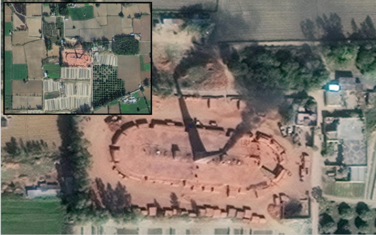
The Rights Lab’s “Slavery from Space” initiative is the world’s first use of data captured by satellites to map and measure slavery, using both new machine learning techniques and citizen science methods (Boyd et al, 2018; Foody et al, 2019). The team has uncovered sites and industries with high levels of slavery thanks to satellites continually capturing data in all corners of the Earth.
RELATED: Decolonizing Ecology for Socially Just Science
Why take part?
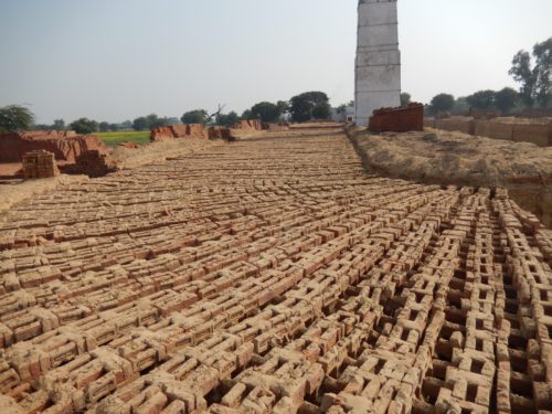
This rapid growth of brick production, and its human and environmental costs, are a serious and urgent concern.
Some 60 to 68 pecent of the 4.4 to 5.2 million brick kiln workers in South Asia are estimated to be working in bonded and forced labour conditions, and 19 percent of brick kiln workers under 18 years of age, according to 2012 reports (ILO, 2015). In the Punjab province of Pakistan, a survey of brick kilns in 2004 found that nearly 90 percent of brick kilns workers were bonded (ILO, 2017); brick kiln owners provide workers with loans upfront, which immediately puts them in debt, entrapping them for a whole season before being paid. Brick kiln owners often pay less than they promise to laborers and pay “per brick,” which works out to payment far less than minimum wage on a timed basis. This makes it so that overtime is the norm for laborers. Child labourers in the Punjab are especially vulnerable, working long hours year-round without access to primary education.
There is also an environmental cost. Traditional brick kilns use a high volume of fertile topsoil to make the bricks and are not energy efficient, resulting in high pollution levels from the chimneys during the firing process. Building construction in India is estimated to grow at a rate of 6.6 percent per year between 2005 and 2030, resulting in a five-times increase in housing stock and a continuous increase in demand for brick and other building materials during this period (McKinsey, 2009).
How do I take part?
Anyone can take part in our “Slavery from Space” Citizen Science effort, which invites volunteers to look at satellite images and vote on whether they contain a brick kiln or not. We will use the data to fine-tune automated image analysis techniques to find kilns over much larger areas and thus widen our search. This will help to build a large-scale picture of the prevalence of brick kilns, as well as provide answers to questions such as why kilns appear where they do, over what time scales do they appear, and whether kilns in which slaves work can be visually distinguished from those in which they do not.
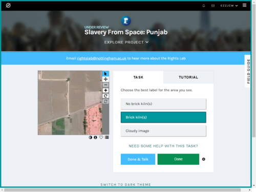
Registration is not required to participate in the project, but it helps us compare your contributions to other users and prevents you from seeing the same image more than once. We have partnered with DigitalGlobe to present you with 100,000 images of India and Pakistan, which must be seen by four or more people by the end of April to coincide with #CitSciDay2019. The race is on!
Julian, a volunteer, said, “This is an easy task that can be done by anyone with a computer and broadband, anywhere, and at any time convenient to the volunteer. There is great satisfaction from the identification of the features, which is done in the knowledge that this is contributing to a wider project.”
The featured image shows an example of a Fixed Chimney Bull’s Trench brick kiln @31.5385546, 75.9813821. Note the emissions from the chimney stack. From Digital Globe’s WorldView-2 satellite system; pan-sharpened natural colour at 50 cm resolution; captured in November 2015.
About the Author
Dr. Jessica Wardlaw is a Research Fellow at the UK’s University of Nottingham’s Rights Lab, working on the use of geospatial and citizen science to tackle modern slavery.
GotScience Magazine is published by the nonprofit Science Connected and is made possible by donations from readers like you. You can support open-access science communication – and it only takes a minute. Donate now.

